Land survey

Size of townships, 13 April 2006, Mo Laidlaw
From 1791, (in Upper and Lower Canada) townships located on navigable rivers were nine miles wide and twelve miles deep, while townships in the interior were squared off in ten mile by ten mile allotments.
From 1869, Dominion land survey, in the west (prairies):
“The basic survey unit is the township, approximately six miles square, each containing 36 sections of one square mile, or 640 acres, plus allowances for road access to each section. Within a township, the sections were numbered from 1 to 36, in a zig-zag pattern, beginning with section 1 in the extreme southeast corner of the township. Each section was in turn subdivided into four quarters (SE, SW, NW, NE) of 160 acres, more or less.”
This system was similar to that used in US, the Public Land Survey System (PLSS) proposed by Thomas Jefferson.
More details and references:
http://www.ubishops.ca/geoh/landscap/bound.htm
http://townshipsheritage.com/article/township-system-1792
Historical geography of Eastern Townships
Township Survey System
With the passage of the 1791 Constitutional Act into law, settlement officially began on the land that was to become the Eastern Townships. The English system of Free and Common Soccage was used to establish land grants in the area, contrary to the traditional French seigneurial long lot system.
It was under the direction of Surveyor-General Joseph Bouchette in 1791 that the area was plotted out using the Township System. Townships located on navigable rivers were nine miles wide (on waterfront) and twelve miles deep, while townships in the interior were squared off in ten mile by ten mile allotments. Throughout the entire area, 1/7 of land was reserved for the crown and another 1/7 was set aside for the Anglican Church, leaving 5/7ths of the total number of lots in each township for settlement. Each riverside township had a total of three hundred and thirty-six lots, 1/3 of a mile wide and one mile deep, and of this, the crown and Protestant Church each had forty-eight lots reserved, while interior townships had a total of three hundred and eight lots, nineteen hundred feet wide and forty-seven hundred feet deep, where the crown and clergy reserved forty-four lots each.
Plan of riverside township: http://www.ubishops.ca/geoh/landscap/plana.htm
Plan of interior township: http://www.ubishops.ca/geoh/landscap/planb.htm
In order to have townships granted for colonization, potential settlers would group together to form a "company of associates". Forty associates were required for a township measuring ten miles by ten miles although the size of each company varied depending on the size of the tract of land that was being sought. An agent was then elected from the company to act between the people and the government, bearing all expenses for the survey of the township. The agent was also expected to construct roads and mills in the settlement area and obtain the signatures of all those who planned to settle on the land grant, and in return, he received additional lots of land from the associates for his efforts. A Warrant of Survey was then issued by the government, and the Surveyor-General was required to survey the land within a six month period. Delays were frequent, but once completed, a document was issued attesting to the fact that the tract of land was petitioned for, surveyed, and was "created, erected, and constituted a township, to be called, known and distinguished by the name of ___________". The company then had to settle the land within one year, and within seven years they had not planted and cultivated seven acres of land, the grant was nullified and all land was given back to the crown.
*************
(http://www.collectionscanada.ca/genealogy/022-912.002-e.html) Link broken
In the province of Quebec, land distribution was originally based on the seigneurial system, established in 1627 and used until 1854.
Seigneuries were granted by the King to members of the "bourgeoisie," members of important families or former military officers. As proprietor of a seigneurie, the "seigneur" had privileges and obligations towards the King or his representative. The "seigneur" granted parcels of land (concessions) on his seigneury to tenants called "censitaires."
Starting in 1763, new lands were granted according to the township system. Quebec was divided into counties that were divided into townships or "municipalités de paroisses."
A list of Crown grants, 1763-1890, arranged by townships within counties, and indexed by grantees, was published in 1891.
Liste des terrains concédés par la Couronne dans la province de Québec, de 1763 au 31 décembre 1890.
Microfilm copies of the records listed in this book are available at the Archives nationales du Québec. Requests for copies should be addressed to:
Archives nationales du Québec
1012, avenue du Séminaire
CP 10450
Sainte-Foy, QC
G1V 4N1
*************
(http://collections.ic.gc.ca/heirloom_series/volume1/chapter5/146-150.htm) Link broken
Canada's Digital Collections
Ontario
The political entity of Upper Canada, created in 1791, had no previous settlement tradition outside the Niagara and Windsor border areas before the coming of the Loyalists in 1784. ... The rectangular 12 mile by nine mile waterfront township and the 10 mile square inland township dominated the Ontario landscape. The original single-front system of larger 200 acre lots was gradually replaced by smaller 100 lot divisions in more manageable double front or 1,000 acre sections. With little mind for rivers, creeks, drumlins, outcrops or swamps, the survey system imposed the layout of roads, spacing of farmsteads, shape of fields, and influenced the variations in land use and patterns of villages at crossroads. While the settler from the United States understood dispersed farms in relative isolation from neighbours and living on one's own land, the immigrant from the British Isles missed the social interaction of the community village.
**************
http://www.afhs.ab.ca/aids/talks/2003_oct_williams.html
Prairie Land Systems
by Gordon Williams
The Dominion Lands Survey System (DLS System)
In 1869, the Dominion of Canada acquired all the land draining in to Hudson Bay (Rupert's Land) from the Governor and Company of Adventurers Trading Into Hudson's Bay (The Hudson's Bay Company). That same year, the Government of Canada began to survey the vast fertile western prairies that came with the purchase of Rupert's Land, anticipating a land rush to the area because virtually all the desirable farmland in central Canada was already taken.
Over a period of fifty years, over 178 million acres, from southern Manitoba to northeastern British Columbia had been staked out on the ground into 1,100,000 homestead-sized quarter sections. This extension of a precise and uniform survey over such an immense area is unique and has never been equalled anywhere else in the world.
The basic survey unit is the township, approximately six miles square, each containing 36 sections of one square mile, or 640 acres, plus allowances for road access to each section. Within a township, the sections were numbered from 1 to 36, in a zig-zag pattern, beginning with section 1 in the extreme southeast corner of the township. Each section was in turn subdivided into four quarters (SE, SW, NW, NE) of 160 acres, more or less.
Homesteads in western Canada consisted of one quarter section, 160 acres, more or less, and each can be uniquely designated within the DLS System. For example, my grandparents' farm in southern Manitoba was the NW quarter of Section 6, Township 14, Range 17, West of the First Meridian (NW6-14-17W1M). The cemetery just east of Calgary on the TransCanada Highway is in NW20-24-28W4M.
*********
http://nationalatlas.gov/articles/boundaries/a_plss.html
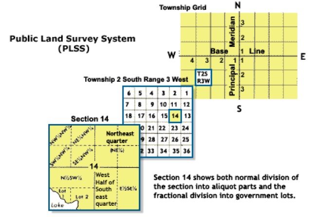
The Public Land Survey System (PLSS)
What is the PLSS?
The Public Land Survey System (PLSS) is a way of subdividing and describing land in the United States. All lands in the public domain are subject to subdivision by this rectangular system of surveys, which is regulated by the U.S. Department of the Interior, Bureau of Land Management (BLM).
The PLSS typically divides land into 6-mile-square townships, which is the level of information included in the National Atlas. Townships are subdivided into 36 one-mile- square sections. Sections can be further subdivided into quarter sections, quarter-quarter sections, or irregular government lots. Normally, a permanent monument, or marker, is placed at each section corner. Monuments are also placed at quarter-section corners and at other important points, such as the corners of government lots. Today permanent monuments are usually inscribed tablets set on iron rods or in concrete. The original PLSS surveys were often marked by wooden stakes or posts, marked trees, pits, or piles of rock, or other less-permanent markers.
The PLSS actually consists of a series of separate surveys. Most PLSS surveys begin at an initial point, and townships are surveyed north, south, east, and west from that point. The north-south line that runs through the initial point is a true meridian and is called the Principal Meridian. There are 37 Principal Meridians, each is named, and these names are used to distinguish the various surveys. The east-west line that runs through the initial point is called a base line. This line is perpendicular to the Principal Meridian.
Source: Principal Meridians and Base Lines, Bureau of Land Management
History
Originally proposed by Thomas Jefferson, the PLSS began shortly after the Revolutionary War, when the Federal government became responsible for large areas west of the thirteen original colonies. The government wished both to distribute land to Revolutionary War soldiers in reward for their service, as well as to sell land as a way of raising money for the nation. Before this could happen, the land needed to be surveyed.
The Land Ordinance of 1785 which provided for the systematic survey and monumentation of public domain lands, and the Northwest Ordinance of 1787 which established a rectangular survey system designed to facilitate the transfer of Federal lands to private citizens, were the beginning of the PLSS. Under Congressional mandate, cadastral surveys (surveys of the boundaries of land parcels) of public lands were undertaken to create parcels suitable for disposal by the Government. The extension of the rectangular system of surveys over the public domain has been in progress since 1785, and, where it applies, the PLSS forms the basis for most land transfers and ownership today.